
Driving to the Range
Getting to the Los Altos Rod and Gun Club Range is usually very easy. However, please review the below directions and road conditions for closures due to northern California's occasional seasonal hazards of flood, mud, earthquake, and fire.
The Range is located about 15 miles south of the San Francisco Bay at 14750 Skyline Boulevard in Los Gatos, California, which is a convenient 15-minute drive from historic downtown Saratoga up scenic Big Basin Way (State Route 9). Simply drive approximately 7 miles to the first stop sign, turn left onto Skyline Boulevard (State Route 35), drive 1.7 miles southeast, slow down as you approach the equestrian crossing, and turn right at the signs to the Range's entrance.
(Click on the map to get driving directions from Google.)
The Range may also be found using the coordinates 37.2391838° N, 122.1088154° W.
Where Are You?
- From Fremont/East Bay:
- Take Interstate 880 south to State Route 85 (West Valley Freeway), then Saratoga Avenue through downtown Saratoga.
- From Gilroy:
- Take Highway 101 north to State Route 85 (West Valley Freeway), then Saratoga Avenue through downtown Saratoga.
- From San Francisco/Penninsula:
- Take Interstate 280 (or Highway 101) southeast to State Route 85 (West Valley Freeway), then Saratoga Sunnyvale Road through downtown Saratoga.
- From Santa Cruz:
- Take Santa Cruz Highway north to State Route 9 through downtown Saratoga. If you don't mind one-lane roads, you may save some distance (and lose some time) by taking the Sumit Road exit to State Route 35 westbound.
Downtown Saratoga
The easiest route to the Range for most visitors is usually through downtown Saratoga, which is on Big Basin Way.
Please note that State Route 9 includes Big Basin Way and Saratoga Los Gatos Road, making a turn at the Saratoga fire station as illustrated in the map below.
At that intersection, Saratoga Sunnyvale Road becomes Saratoga Los Gatos Road and Saratoga Avenue becomes Big Basin Way.
To get to the Range from the intersection at the fire station:
- Travel 7.3 miles west up Big Basin Way (State Route 9).
- Turn left at the Saratoga Gap, at the intersection of Big Basin Way and Skyline Boulevard (State Route 35).
- Travel 1.7 miles southeast along Skyline Boulevard (State Route 35) to the Range's entrance.
(Click on the map to get driving directions from Google.)
Routes to the Range
All routes include some mountain driving. Please be courteous to faster drivers behind you by using turnouts to let them pass, and have patience when behind slower drivers.
State routes to and near the Range include:
- State Route 9: Big Basin Way
- State Route 17: Santa Cruz Highway
- State Route 35: Skyline Boulevard
- State Route 84: Woodside Road/La Honda Road
- State Route 85: West Valley Freeway
- State Route 92: J. Arthur Younger Freeway
Please check for traffic and road closures, especially during winter months when there could be snow and/or mudslides. If using the CHP Traffic Incident Information Page, please select the Golden Gate division.
Via State Route 9 (Big Basin Way) | |||
 Big Basin Way |
The Range may usually be reached easily from Saratoga via scenic Big Basin Way (State Route 9). Big Basin Way may be reached from the northeast through downtown Saratoga, and from the north via Pierce Road or Stevens Canyon Road (which in some places has only one lane). From the Saratoga fire station, travel 7.3 miles west up Big Basin Way to Skyline Boulevard (State Route 35). |
||
From Saratoga Gap | |||
Big Basin Way (30 MPH) |
& |  Skyline Blvd |
The Range may be reached from the intersection of scenic Big Basin Way (State Route 9) and Skyline Boulevard (State Route 35) at Saratoga Gap. From the 4-way stop intersection, travel 1.7 miles southeast along Skyline Boulevard to the Range's entrance. |
On State Route 35 (Skyline Boulevard) | |
Skyline Blvd |
Skyline Boulevard (State Route 35) may be accessed from the northwest via Big Basin Way (State Route 9), Page Mill Road (County Route G3, Oregon Expressway north of El Camino Real), La Honda Road/Woodside Road (State Route 84), and the J. Arthur Younger Freeway (State Route 92). From the east, Skyline Boulevard may be accessed via Santa Cruz Highway and the exits for the West Valley Freeway (State Route 85), Saratoga Los Gatos Road (State Route 9), or Bear Creek Road. The Range's entrance is 0.9 miles west of the entrance for Castle Rock State Park. |
Range Entrance
When approaching from either direction, watch for the signs for the equestrian crossing (horse with rider) and range entrance 650 feet and 450 feet (respectively) before the entrance to the Range on the left side of the road.
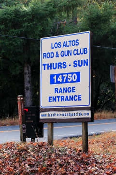
Watch for signs like this one at the Range Entrance on Skyline Boulevard.
Via Santa Cruz Highway | |
 Santa Cruz Hwy |
From Santa Cruz Highway (California State Route 17), exit at:
From the Bear Creek Road exit, the best route is north on Montevina Road for 0.3 miles to Black Road (which is narrow and in many places has only one lane). Travel west on Black Road for 4.5 miles to Skyline Boulevard and turn right. Travel northwest on Skyline Boulevard for 4.7 miles. Skyline Boulevard may be reached directly via Bear Creek Road, although Skyline Boulevard has only one lane between Bear Creek Road and Black Road. Travel northwest on Skyline Boulevard for 8.7 miles. Gist Road also connects Black Road to Skyline Boulevard, but has only one lane and is extremely narrow and has many sharp curves. Travel northwest on Skyline Boulevard for 6.3 miles. |
Via State Route 84 (Woodside Road/La Honda Road) | |
 Woodside Road/ La Honda Road |
From Woodside Road/La Honda Road (State Route 84), travel 15.4 miles southeast. |
Via State Route 85 (West Valley Freeway) | |
 West Valley Freeway |
From the West Valley Freeway (State Route 85), exit atSaratoga Avenue and continue southwest into downtown Saratoga. There, it will become Big Basin Way. Continue following directions for State Route State Route 9 (Big Basin Way). |
Via State Route 92 (J. Arthur Younger Freeway) | |
 J. Arthur Younger Fwy |
From the J. Arthur Younger Freeway (State Route 92) at the northwest end of Skyline Boulevard (State Route 35), travel southeast 27.8 miles. |